 Download full
Anomalous Echoes Captured by a B-52 Airborne Radarscope Camera
2. General Description of Radarscope Photographs
All 14 photographs show the illuminated bearing ring and tube face of a 10-inch diameter circular Plan Position Indicator (PPI). There is a consecutive numbered sequence of 13 frames showing the radarscope in a 360-degree surveillance mode called Station Keep, and a 14th frame showing the same scope in an unidentified sector scan mode.
2-1. The 13 Numbered Frames
A marker strobe on the PPI paints from the centre-spot out to the bearing ring and indicates the aircraft heading. In all cases the aircraft heading marker is on the same azimuth, 122 degrees. (A secondary marker appears in each photo, displaced clockwise from the heading marker by the same angle. This is understood to be a variable azimuth marker normally used together with a variable range marker - not appearing on scope in the radar mode selected - as a cross-hair for bomb targeting and navigation purposes. The position of this strobe is not believed to be significant.)
A chronological meter and analogue clock shown on 13 of the photographs, numbered 771 to 783, prove that they are an unbroken sequence. A handwritten data plate carries the words "Bismarck" and "St. George" (locations in North Dakota, and Utah respectively, relating to the flight plan), including, the date, aircraft identification, names of operators (Richey and McCaslin), and radar system AN designation "ASQ 38" proving that the photos relate to the case in question.
The update rate is 3 seconds, approximately synchronised with the 3-second scan rate of the radar. (There is evidence of a possible discrepancy of about 2%, which by frame 783 accumulates to between 1/2 and 1 second.) The camera objective lens is integral to the CRT and the PPI image is routed to an externally-mounted camera by a system of prisms.
Each photo is a time exposure of one rotation of the PPI trace with a 50 millisecond interval for film advance between frames. The clock, data plate, and numbering meter are double-exposed onto the film via a separate optical pathway.
The radar (rotating antenna mounted beneath the nose of the B-52H) is an essentially downward-pointing bombing-navigation radar that scans the ground and air in various modes. Consequently the PPI shows a dark central region, known as the "altitude hole", surrounded by an annulus of fairly uniform bright echo which is ground return. Certain details inside this bright area appear to be topographical features. The altitude hole extends to approximately 1/3 of the PPI radius and is almost the same diameter on all photos, reducing in size only slightly in relation to the range rings over the series of 13 scans.
Concentric bright range rings are visible inside the altitude hole, having a spacing of one half-mile (nautical), while corresponding to a maximum display range of approximately 5 NM. However, no range-scale indicator is shown, and the range representation is slightly nonlinear owing to a short-range TR (transmit/receive) "hole" in the middle of the display (Note 2).
Most of the photographs also show rather discrete echoes of varying brightness inside the altitude hole at varying azimuths, apparently indicating a target or targets in the air near the B-52 at slant ranges of a mile or two. These unidentified echoes and their characteristics will be described in detail presently.
The 13 photographs also all show a bright smudge to the left of the centre-spot which has been tentatively identified (by Dr. Richard Haines) as a ghost image of the bright centre-spot itself, doubly reflected from the camera lens onto the tube face and thence back into the camera. (However, see also Note 2).
The photos vary somewhat in contrast and resolution. The distinctness of the heading marker and range rings tends to decrease through the series 771-782, whilst speckles of noise around the periphery of the altitude-hole tend to increase in density. On frame 783 these heading and range markers appear more distinct again, the speckling has disappeared and some fugitive ground features seem to become more visible. The markers are generated electronically by a circuit that brightens the scope trace, and some of these changes may be caused by manual adjustments to the video amplifier gain.
Frames 772-783 all record full 360-degree scans, each showing a set of complete range rings, whilst 771 captures approximately half of one 360-degree scan, showing semicircular range rings where only half of the scope has been written on. Frame 771 appears to show the camera being switched on in mid-scan (see Section 5-3).
2-2. The 14th Frame
The remaining 14th photo differs, showing a 48-degree sector-scan of terrain, dense with ground return. The azimuth-marker tick on the bearing ring appears to be in the same position in this frame, and the display orientation appears to be identical (approximately a heading-up presentation as photographed, with 120 degrees at the top of the picture), but neither the clock nor the counter nor the data plate are visible to the right of the PPI. In place of these are three illuminated lamps, indicating that the radar is switched into a different mode with a different range scale (see Section 4).
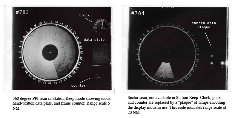
Fig. 1. Comparison of display modes in 13-frame sequence (left) and in 14th frame (right).
A small dark feature visible against the ground return on frames 772-783 appears to match a similar feature on the 14th photo. In 772 this feature (appearing like a small "lake" and discussed as Feature #3 in Section 5-1) appears at 312 degrees, about a half-radius out from the centre spot. This feature is also detectable on Frame 771 in a region of the tube not yet written on by the rotating scope trace, and partly for this reason is believed to be a system artifact. A corresponding display artifact or camera artifact on the sector scan, also appearing at 312 degrees at almost the same distance from the centre spot as in frame 783. This indicates that the sector scan photo probably shows the same scope in a different display mode, imaged by the same camera.
There is also a small (unexplained) systematic displacement of this artefact over the sequence 772-783 (Section 5-1), and its position on the sector scan suggests that this frame may have been taken a few seconds after frame 783, possibly as #784. Based on internal evidence of the migration of the small artifact mentioned above this sector scan will tentatively be numbered frame 784 here. On the other hand there are anomalies (see Section 4) so this is very uncertain; however there appear to be no unidentified echoes on this scan so the matter is of secondary importance. The rest of this analysis is principally concerned with the homogeneous sequence numbered 771-783, whose main features will now be described briefly.